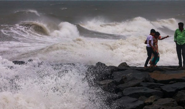
The severe cyclonic storm ‘Ditwah’ over the southwest Bay of Bengal has significantly weakened, de-intensifying into a deep depression, according to the India Meteorological Department (IMD). The system is continuing its trajectory nearly northwards, running parallel to the north Tamil Nadu and Puducherry coasts at a speed of 10 kmph.
The IMD forecasts that the deep depression is expected to weaken further into a depression by Monday noon (December 1), though coastal regions remain on high alert for heavy rainfall and gusty winds.
Latest Track and Impact
In its 2:00 AM update, the IMD positioned the centre of the deep depression approximately 50 km from the north Tamil Nadu-Puducherry coasts.
- Location Update: As of 11:30 PM on Sunday, the system was centered about:
- 90 km south-southeast of Chennai (India).
- 90 km east-southeast of Puducherry (India).
- 110 km east-northeast of Cuddalore (India).
- Forecast Track: The deep depression is very likely to move nearly northwards along the North Tamil Nadu-Puducherry coasts and remain over the southwest Bay of Bengal at a minimum distance of about 30 km by Monday morning.
- Red Alert Recap: The IMD had previously issued a Red Category warning for north Tamil Nadu, Puducherry, and nearby south Andhra Pradesh coasts due to the potential for extremely heavy rainfall.
Rainfall and Wind Warnings
Even in its weakened state, the system is expected to bring substantial rainfall and strong winds:
- Rainfall: Heavy to very heavy rain may occur in isolated areas of Tiruvallur, Kancheepuram, Chennai, Chengalpattu, Vellore, and Ranipet districts. Light to moderate rain is expected in a few places across Tamil Nadu and the Puducherry and Karaikal region, with thunderstorms and lightning possible in one or two areas.
- Wind Speed: Gale winds of 60-70 kmph, gusting up to 80 kmph, are likely over the north coastal parts of Tamil Nadu and the Puducherry and Karaikal areas. Squally winds of 55-65 kmph, gusting to 75 kmph, are also expected over nearby north coastal Tamil Nadu districts and the south coastal Tamil Nadu region.
- Other States: Light to moderate rainfall is expected in south coastal Andhra Pradesh and Rayalaseema, with heavy rain at isolated locations. Odisha is also expected to see heavy rain in isolated areas of the south.
Casualties and Relief Efforts
The severe weather triggered by the cyclone has unfortunately resulted in fatalities in the region:
- Tamil Nadu Deaths: State revenue and disaster management minister KKSSR Ramachandran confirmed that three people have died in rain-related incidents in Tamil Nadu as of Sunday.
- Sri Lanka Devastation: The disaster’s impact was far more severe in neighbouring Sri Lanka, where the death toll from floods and landslides has climbed to 334, with nearly 400 people missing and over 1.3 million affected across the island.
- Operation Sagar Bandhu: The High Commission of India in Sri Lanka confirmed the evacuation of the final group of stranded Indian passengers under Operation Sagar Bandhu. External Affairs Minister S. Jaishankar announced that another Indian Air Force aircraft arrived in Colombo on Sunday carrying disaster-response supplies.
School and College Closures (December 1)
Due to the heavy rainfall and high alert, several educational institutions have been closed:
- Puducherry: Home and Education Minister A. Namassivayam announced that all private and government-aided institutions across the four regions of Puducherry are closed today, Monday (December 1).
- Tamil Nadu: While several districts in Tamil Nadu had announced school closures previously, official confirmation for all districts on December 1 is pending. Parents and students are strongly advised to check with their respective district collectors or school authorities for the latest updates.


